Landslide Disaster Management in India
Landslides are the downward movement of rock, soil, and debris down a slope under the direct influence of gravity
It is a major disaster in hilly and mountainous regions. Landslides often occur due to heavy rainfall, earthquakes, slope instability, deforestation, road construction, mining and unplanned development in fragile regions.
In India, landslides are common in the Himalayan region, North-East India, Western Ghats, Eastern Ghats and some parts of the Nilgiris. They cause loss of life, damage to roads, houses, bridges, hydropower projects, forests and agricultural land.
Causes of Landslides
- Geological Weak material
- Weakness in the composition and structure of rock or soil may also cause landslides.
- Erosion
- Erosion of slope toe due to cutting down of vegetation, construction of roads might increase the vulnerability of the terrain to slide down.
- Intense rainfall
- Storms that produce intense rainfall for periods as short as several hours or have a more moderate intensity lasting several days have triggered abundant landslides. Heavy melting of snow in the hilly terrains also results in landslides.
- Earthquake shaking has triggered landslides in many different topographic and geologic settings. Rock falls, soil slides and rockslides from steep slopes involving relatively thin or shallow dis-aggregated soils or rock, or both have been the most abundant types of landslides triggered by historical earthquakes.
- Volcanic eruption Deposition of loose volcanic ash on hillsides commonly is followed by accelerated erosion and frequent mud or debris flows triggered by intense rainfall.
- Glacial Activity
- Melting glaciers, snowmelt and glacial lake outburst floods may destabilise slopes.
- Human-Induced Causes
- Deforestation
- Trees bind the soil through their roots.
- Removal of vegetation reduces slope stability and increases runoff, leading to landslides.
- Road Construction
- Cutting hillsides for roads without proper slope protection weakens slopes.
- Improper drainage along roads also increases the risk of landslides.
- Mining and Quarrying
- Mining, blasting and quarrying disturb rock structure.
- This creates instability and may trigger landslides.
- Hydropower and Infrastructure Projects
- Large infrastructure projects may involve tunnelling, blasting, slope cutting and deforestation.
- If not scientifically planned, they increase slope instability.
Type of Landslides
- Falls: Abrupt movements of materials that become detached from steep slopes or cliffs, moving by free-fall, bouncing, and rolling.
- Flows: General term including many types of mass movement, such as debris flow, debris avalanche, lahar, and mudflow.
- Creep: Slow, steady downslope movement of soil or rock, often indicated by curved tree trunks, bent fences or retaining walls, tilted poles or fences.
- Debris flow: Rapid mass movement in which loose soils, rocks, and organic matter combine with entrained air and water to form slurry that then flows down slope, usually associated with steep gullies.
- Debris avalanche: A variety of very rapid to extremely rapid debris flow.
- Lahar: Mudflow or debris flow that originates on the slope of a volcano, usually triggered by heavy rainfall eroding volcanic deposits, sudden melting of snow and ice due to heat from volcanic vents, or the breakout of water from glaciers, crater lakes or lakes dammed by volcanic eruptions
- Mudflow: Rapidly flowing mass of wet material that contains at least 50 per cent sand, silt, and clay-sized particles.
- Lateral spreads Often occur on very gentle slopes and result in nearly horizontal movement of earth materials. Lateral spreads usually are caused by liquefaction, where saturated sediments (usually sands and silts) are transformed from a solid into a liquefied state, usually triggered by an earthquake.
- Slides: Many types of mass movement are included in the general term “landslide.” The two major types of landslides are rotational slides and translational landslides.
- Topple: A block of rock that tilts or rotates forward and falls, bounces, or rolls down the slope
Impact of Landslides
- Human Impact
- Landslides can cause deaths, injuries, displacement and psychological trauma.
- People may be buried under debris or trapped due to road blockages.
- Poor households living on unsafe slopes are more vulnerable.
- Infrastructure Impact
- Landslides damage roads, highways, railway lines, bridges, houses, schools, hospitals, electricity lines and communication networks.
- Economic Impact
- Landslides damage agriculture, tourism, transport, hydropower projects and local markets.
- They increase the cost of repair, reconstruction, relief and rehabilitation.
- Frequent landslides affect trade and mobility in mountain regions.
- Environmental Impact
- Landslides destroy forests, disturb hill slopes, damage river systems and increase soil erosion.
- They may block rivers and create temporary lakes, which can later burst and cause floods.
- Agricultural Impact
- Landslides damage terraced fields, orchards and grazing lands.
- Soil erosion reduces fertility and long-term agricultural productivity.
- Social Impact
- Landslides disrupt education, healthcare, transport and daily life.
- Remote villages may remain cut off for days due to road damage.
- Relocation may also create social and livelihood difficulties.
- Administrative Impact
- Landslides create challenges for rescue, evacuation, relief supply and restoration of essential services.
- In mountain areas, difficult terrain and bad weather make disaster response more complex.
- Secondary Hazards
- Landslides may trigger or worsen:
- Flash floods
- River blockages
- Dam-like lake formation
- Road accidents
- Forest degradation
- Soil erosion
- Damage to hydropower projects
- Disruption of drinking water supply
Distributional Pattern
The Indian subcontinent, with diverse physiographic, seismic, tectonic and climatological conditions is subjected to varying degree of landslide hazards; the Himalayas including Northeastern mountains ranges being the worst affected, followed by a section of Western Ghats and the Vindhyas.
Removal of vegetation and toe erosion have also triggered slides.
Torrential rainfall on the deforested slopes is the main factor in Peninsular India namely in Western Ghat and Nilgiris. Human intervention by way of slope modification has added to this effect
Vulnerability Profile
- Himalayan Region
- Jammu and Kashmir, Himachal Pradesh, Uttarakhand, Sikkim and Arunachal Pradesh are highly landslide-prone.
- The Himalayas are young, fragile, tectonically active and heavily affected by rainfall, earthquakes and road construction.
- North-East India
- States such as Assam, Meghalaya, Nagaland, Manipur, Mizoram and Arunachal Pradesh face frequent landslides due to high rainfall, steep slopes and fragile geology.
- Western Ghats
- Kerala, Karnataka, Maharashtra, Goa and Tamil Nadu face landslides due to heavy rainfall, deforestation, quarrying and slope modification.
- Parts of Odisha, Andhra Pradesh and Tamil Nadu are vulnerable, especially where slopes are disturbed by rainfall and human activity.
Disaster Risk Reduction Measures
Structural Measures
- Slope Stabilisation
- Unstable slopes should be strengthened through scientific engineering methods.
- This may include slope trimming, terracing, benching and reinforcement.
- Retaining Walls
- Retaining walls provide support to slopes and prevent soil or rocks from sliding.
- They are useful along roads, settlements and critical infrastructure.
- Rock Bolting and Netting
- Rock bolts and wire mesh can hold loose rocks in place.
- This helps reduce rockfall along highways and steep slopes.
- Drainage Management
- Proper drainage is one of the most important landslide control measures.
- Surface and subsurface drainage systems should be developed to remove excess water from slopes.
- Blocked drains should be regularly cleared.
- Afforestation and Vegetative Cover
- Trees, grasses and shrubs help bind soil and reduce surface runoff.
- Plantation of suitable native species can improve slope stability.
- Check Dams and Gully Control
- Small check dams and gully plugs help reduce water flow speed and soil erosion.
- They are useful in landslide-prone catchment areas.
- Protective Barriers
- Barriers, catch fences and rockfall shelters can protect roads and settlements from falling debris.
- Safe Road Construction
- Hill roads should be constructed with proper slope cutting, retaining structures, drainage and debris disposal.
- Unscientific road widening should be avoided.
- Strengthening Critical Infrastructure
- Hospitals, schools, bridges, power stations and communication systems in hilly areas should be designed with landslide risk in mind.
Non-Structural Measures
- Landslide Hazard Zonation Mapping
- Hazard zonation maps identify areas with high, moderate and low landslide risk.
- These maps help in land-use planning, construction regulation and disaster preparedness.
- Land-Use Planning
- Construction should be restricted in high-risk zones.
- Settlements, hotels, resorts and infrastructure projects should not be allowed on unstable slopes.
- Early Warning Systems
- Rainfall-based early warning systems can help detect landslide risk.
- Monitoring of rainfall, slope movement, soil moisture and cracks can provide useful alerts.
- Regulation of Construction
- Building activities in hill areas should follow slope safety norms.
- Unplanned construction, illegal cutting of slopes and unsafe buildings should be controlled.
- Environmental Impact Assessment
- Large infrastructure projects in fragile hill regions should undergo strict environmental and geological assessment.
- Risk from blasting, tunnelling, drainage changes and slope cutting should be properly studied.
- Public Awareness
- People living in landslide-prone areas should know warning signs such as cracks in walls, tilted trees, sudden water seepage, unusual sounds and small rockfalls.
- Awareness helps communities respond quickly.
- Community Preparedness
- Local communities should be trained in evacuation, first aid, emergency communication and relief support.
- Community volunteers are very important in remote hill areas.
- Monitoring and Research
- Scientific monitoring of vulnerable slopes should be strengthened.
- Use of remote sensing, drones, GIS, rainfall data and ground sensors can improve risk assessment.
- Relocation from High-Risk Areas
- Where slopes are extremely unstable, relocation of vulnerable households may be necessary.
- Relocation should be humane, livelihood-sensitive and community-based.
- Insurance and Financial Protection
- Insurance and compensation mechanisms can help affected families recover from losses.
Challenges in Landslide Management in India
- Unplanned Development in Hill Areas
- Rapid construction of houses, hotels, roads and infrastructure has increased slope instability.
- Many projects do not properly consider geological fragility.
- Weak Enforcement of Regulations
- Building norms, land-use restrictions and environmental safeguards are often poorly implemented.
- This increases exposure to landslide risk.
- Deforestation and Slope Disturbance
- Removal of vegetation weakens soil binding.
- Slope cutting and quarrying further increase vulnerability.
- Poor Drainage Management
- Blocked or poorly designed drains allow water to seep into slopes.
- This is a major trigger of landslides during heavy rainfall.
- Lack of Local-Level Hazard Mapping
- Many villages and towns do not have detailed landslide hazard maps.
- Without mapping, risky construction continues in vulnerable areas.
- Limited Early Warning Systems
- Accurate landslide early warning is difficult because landslides depend on rainfall, geology, slope angle, soil moisture and human disturbance.
- Many vulnerable areas still lack real-time monitoring.
- Climate Change
- Extreme rainfall events are increasing in many regions.
- This increases the frequency of landslides, flash floods and slope failures.
- Difficult Terrain
- Mountainous terrain makes rescue, evacuation and relief operations difficult.
- Road blockages can delay emergency response.
- High Vulnerability of Poor Households
- Poor families often live on unsafe slopes or near unstable hill roads.
- They have limited capacity to relocate or rebuild safely.
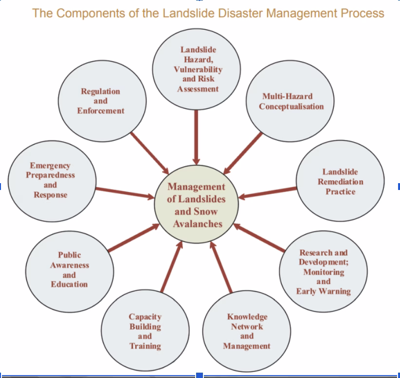
NDMA Guidelines
- Highlights of Important Recommendations
- Developing and continuously updating the inventory of landslide incidences affecting the country.
- Landslide hazard zonation mapping in macro and meso scales after identification and prioritisation of the areas in consultation with the Border Roads Organisation, state governments and local communities.
- Taking up pilot projects in different regions of the country with a view to carry out detailed studies and monitoring of selected landslides to assess their stability status and estimate risk.
- Setting pace setter examples for stabilisation of slides and also setting up early warning systems depending on the risk evaluation and cost-benefit ratio.
- Complete site specific studies of major landslides and plan treatment measures, and encourage state governments to continue these measures.
- Setting up of institutional mechanisms for generating awareness and preparedness about landslide hazard among various stakeholders.
- Enhancing landslide education, training of professionals and capacity development of organisations working in the field of landslide management.
- Capacity development and training to make the response regime more effective.
- Development of new codes and guidelines on landslide studies and revision of existing ones.
- Establishment of an autonomous national centre for landslide research, studies and management
- Guidelines
- Landslide Hazard, Vulnerability and Risk Assessment: This includes delineating areas susceptible to landslide hazards and status of landslide hazards in different areas and to assess the resources at risk due to these hazards as per the requirement of communities and for planning and decision making purposes. This also involves site specific studies of landslides and preparation of landslide inventory. The study of snow avalanches can also be included in this.
- Multi-Hazard Conceptualisation: Integrating landslide concerns into multi-hazard disaster management plans at different levels for effective risk assessment, mitigation and response
- Landslide Remediation Practice: Encouraging implementation of successful landslide remediation and mitigation technologies, and execution of pace setter examples in mitigation and remediation strategies to build confidence amongst the affected communities. This also includes monitoring of landslides and development of early warning systems.
- Research and Development; Monitoring and Early Warning: The study of landslide hazards is an area that requires active research. Unlike many other violent acts of nature, landslide hazards can be mapped out, predicted and contained, provided that a synergy of detailed plans, an aware community and scientific research are established. Research is of critical importance in managing landslides. Developing a predictive understanding of landslide processes and triggering mechanism; regional real-time landslide warning systems based on threshold values of rainfall; real-time monitoring and establishing early warning systems in case of landslides that pose substantial risk to developmental gains; risk assessment and developing methodologies for assessing the potential co-seismic slides are some of the important fields of research that need immediate attention.
- Knowledge Network and Management: Establishing an effective system for gathering information on landslides, loss assessment resulting from landslides, and the effective dissemination of technical information and maps is an essential component of the disaster management process. A web portal—the India Disaster Knowledge Network (IDKN) will be launched at the National level.
- Capacity Building and Training: Developing institutional capacity and training for geoscientists, engineers, and planners is necessary for effective management of the landslide hazard. The directorates of mining and geology of the state governments require particular attention in this regard as these can be focal points of most scientific studies for landslides in the future. Risk assessment methodology, detailed site specific studies, etc., have to be standardised and existing codes for landslide related practices have to be suitably modified.
- Public Awareness and Education: Effective communication of landslide hazard issues to the affected communities through education, public awareness programmes, posters, audio-visual aids, media campaigns, etc., is required
- Emergency Preparedness and Response: Development of coordinated landslide rapid response capability involving scientists, engineers, local authorities, the National Disaster Response Force and paramilitary forces. Rescue, relief and rehabilitation are covered in this component.
- Regulation and Enforcement: Establishment of a techno-legal mechanism of landslide hazard assessment and mitigation with provisions for enforcing compliance thereof are important
Way Forward
- Prepare detailed landslide hazard zonation maps for vulnerable regions.
- Strictly regulate construction in high-risk hill slopes.
- Make slope stability assessment mandatory before road, tunnel, dam and building projects.
- Improve drainage systems along hill roads and settlements.
- Promote scientific slope stabilisation measures such as retaining walls, rock bolting, netting and terracing.
- Strengthen afforestation and use native vegetation to bind soil.
- Control quarrying, blasting and unscientific hill cutting.
- Develop rainfall-based landslide early warning systems.
- Use drones, remote sensing, GIS and ground sensors for monitoring vulnerable slopes.
- Train engineers, contractors, masons and local officials in safe hill construction.
- Conduct regular community awareness programmes and mock drills.
- Prepare village-level and district-level landslide response plans.
- Relocate people from extremely high-risk zones with proper livelihood support.
- Build resilient roads, bridges and communication systems in hill areas.
- Integrate climate change adaptation into mountain development planning.
Landslides are a serious disaster risk in India’s hilly and mountainous regions. Their impact is increasing due to climate change, unplanned development, deforestation and fragile geology. Effective landslide management requires a shift from post-disaster relief to risk reduction through hazard mapping, slope stabilisation, safe construction, ecological protection, early warning and community preparedness.
Sample Mains Questions
Q1. Discuss the structural and non-structural measures for landslide risk reduction.
(250 words, 15 marks)
Q2. Unplanned development in hill areas has increased landslide vulnerability in India. Analyse.
(250 words, 15 marks)
Q3. Explain the significance of landslide hazard zonation mapping in disaster risk reduction.
(150 words, 10 marks)
✍️ Curated by InclusiveIAS Editorial Team
At InclusiveIAS, our editorial team is led by experts who have successfully cleared multiple stages of the UPSC Civil Services Examination, including Mains and Interview. With deep insights into the demands of the exam, we focus on crafting content that is accurate, exam-relevant, and easy to grasp.
Whether it’s Polity, Current Affairs, GS papers, or Optional subjects, our notes are designed to:
Break down complex topics into simple, structured points
Align strictly with the UPSC syllabus and PYQ trends
Save your time by offering crisp yet comprehensive coverage
Help you score more with smart presentation, keywords, and examples
🟢 Every article, note, and test is not just written—but carefully edited to ensure it helps you study faster, revise better, and write answers like a topper.